Biparjoy changed its course; Cyclone about 910km south of Karachi in the Arabian Sea
Cyclone Biparjoy is expected to make landfall in the Indian states of Gujarat within the next 24 hours.
Biparjoy, a very severe cyclonic storm, which initially posed no threat to the coastal areas of Pakistan, on Saturday changed its course.
Following the development, The Pakistan Meteorological Department (PMD) advised authorities in Sindh and Balochistan on Saturday to remain alert as the storm lay at a distance of “about 910km south of Karachi, 890km south of Thatta and 990km southeast of Ormara”.
Subsequently, the provincial disaster management authorities (PDMAs) of Sindh and Balochistan have been put on alert and fishermen had also been advised to not venture into the sea.
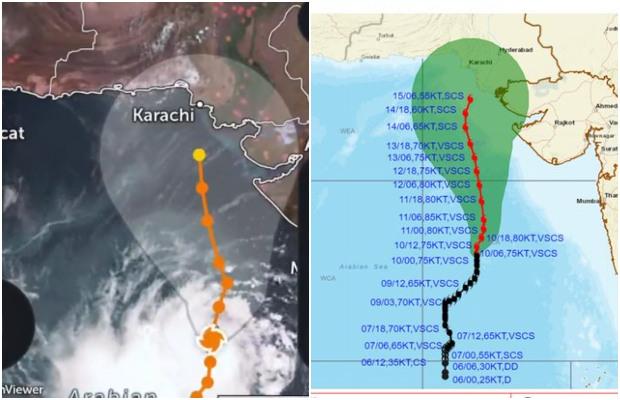
National Disaster Management Authority Pakistan is constantly following the development of the Very Severe Cyclonic Storm Biparjoy and issued a warning in this regard.
NEOC Update: Very Severe Cyclonic Storm (VSCS) #BIPARJOY status.
Development path based on intl weather models is for proactive measures against likely impacts. It's an evolving situation& impact will only be certain with further development of sys.
Source: Zoom Earth pic.twitter.com/UgElpPDhX9— NDMA PAKISTAN (@ndmapk) June 10, 2023


According to the chief Meteorologist Sardar Sarfraz, the severe cyclone in the Arabian Sea is moving north and northeast.
The system may change direction slightly and move towards the northwest, this track includes the coastal areas of Oman and Pakistan and Mara and Sonmiani, he added.
Sardar Sarfraz said that it cannot be said definitively about the storm which coastal areas may be affected while the second track of the storm may be the coastal belt of Gujarat and Sindh.
Cyclone’s intensification calls for heightened vigilance in coastal regions:
- Fishermen are advised not to venture into the open sea from tomorrow, 11 June 2023 onwards till the system is over as the Arabian Sea conditions may get very rough/high accompanied by high tides along the coast.
- With its probable north-northeast track, the rain-thunderstorm with some heavy falls & squally winds is expected on the Sindh-Makran coast from 13 June evening/night onwards.
- Squally (high-intensity) winds may cause damage to loose & vulnerable structures.
- Sea conditions are very high/phenomenal around the system canter with a maximum wave height of 25-28 feet.


