Cyclone Biparjoy moving towards coastal areas of Pakistan
PMD's cyclone warning center in Karachi is monitoring the system
Cyclone Biparjoy is moving towards the coastal areas of Pakistan, authorities put on alert on Friday!
The government on Friday advised authorities in Sindh and Balochistan to remain alert following the advisory issued by the Pakistan Meteorological Department (PMD).
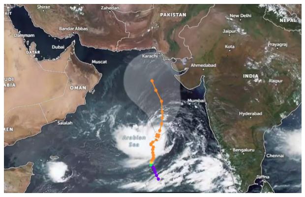
A “very severe” cyclonic storm, Biparjoy, over the Arabian Sea is reported to be moving towards Pakistan’s coastal areas.
According to an advisory issued by PMD, Cyclone Biparjoy had changed its course and slowly tracked in the north-northeast direction during the past 12 hours.
It now lies near latitude 14.8°N and longitude 66.5°E at a distance of about 1,120km south of Karachi.


“Maximum sustained surface winds are 130-150km/hour gusts and 160km/hour around the system center,” PMD notified, adding that “the favorable environmental conditions including the sea surface temperature of 30-32°C, low vertical wind shear and upper-level divergence were still supporting the system to intensify further.”
“Owing to a shift in upper-level steering winds, there is uncertainty in global models’ opinion regarding the track forecast of the cyclone, with some taking it to the Oman-Pakistan western coast and others indicating towards the Indian Gujarat-Pakistan Sindh coast,” the MET office added.
“Considering this uncertainty, the system is likely to keep tracking further north/northeastward during the next 2 days.”
PMD’s cyclone warning center in Karachi is monitoring the system.
The advisory issued by the Pakistan Meteorological Department (PMD) stated:
- Fishermen are advised not to venture into the open sea from Monday, 12 June, onwards till the system is over as the Arabian Sea conditions may get very rough/high accompanied by high tides along the coast.
- With its probable northeast track, the rain-thunderstorm — with some heavy falls and squally winds — is expected on the Sindh-Makran coast from 13 June night to 14 June morning.
- Sea conditions are very high/phenomenal around the system center with a maximum wave height of 25-28 feet.
Meanwhile, the National Disaster Management Authority (NDMA) following the development, in a statement issued on Friday said that the situation was continuously being monitored by the National Emergencies Operation Centre.
“The Chairman NDMA instructed PDMAs to conduct a local-level needs assessment, deploy manpower and machinery, and work closely with relevant departments,” NDMA said.
NDMA also urged the public to stay informed and follow local authorities’ guidance in any emergency situation caused by the cyclone.
Currently no major threats to coastal areas of🇵🇰 . Session focused on proactive measures to manage disasters effectively.
— NDMA PAKISTAN (@ndmapk) June 9, 2023
NDMA urges public to stay informed and follow local authorities’ guidance in any emergency situation due to the cyclone.#Biparjoy
Source: Zoom Earth pic.twitter.com/GFbha1y5em
There is a greater likelihood of the cyclone getting weak and making landfall over Kutch/Gujrat. While in the coastal areas of Sindh, Pakistan there is a chance of high tides and some showers and gusty winds between 13-16th June.