Cyclone Biperjoy further intensifies, next 36 hours declared critical
Citizens urged to stay away from shorelines as Cyclone Biparjoy now 700km away from Karachi
Cyclone Biperjoy further intensified on Sunday while the next 36 hours have been declared critical!
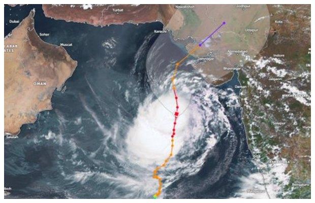
As per the MET office prediction, Cyclone Biparjoy which is presently 700 km south of Karachi will continue to move northward till the morning of June 14 and then move Northeast and make landfall between Keti Bunder in Sindh and the Indian state of Gujarat on the afternoon of June 15.
The Pakistan Meteorological Department (PMD) Sunday warned that a Very Severe Cyclonic Storm (VSCS) Biparjoy in the Arabian Sea is moving northward in the last 12 hours and after gaining strength it has now turned into an Extremely Severe Cyclonic Storm (ESCS).
According to the Meteorological Department, the storm Biperjoy in the Arabian Sea has become more intense, and the distance of the cyclone from Karachi is only 700 km.
As per the Sunday morning brief, the cyclone lies near latitude 18.1°N and longitude 67.5°E at a distance of about 760 kilometers south of Karachi, 740 kilometers south of Thatta, and 840 kilometers southeast of Ormara.


Dr Sardar Sarfaraz, the chief meteorologist of PMD in Sindh, said, the cyclone system will maintain its northward trajectory. Maximum sustained surface winds are 150-160 kilometers per hour with gusts 180 kilometers per hour around the system center within and sea conditions are phenomenal around the system canter with maximum wave height 35 to 40 feet.
Fishermen have been advised not to venture into the open sea till the system is over by 17 June, as the Arabian Sea conditions may get very rough/high accompanied by high tides along the coast.
MET warns of possible impacts:
- With its probable approach to the southeast Sindh coast, widespread wind-dust/thunderstorm rain with some very heavy/extremely heavy falls accompanied by squally winds of 80-100 kilometers per hour likely in Thatta, Sujawal, Badin, Tharparker, and Umerkot districts during June 13-17.
- Dust/thunderstorm-rain with few heavy falls and accompanied by squally winds of 60-80 kilometers per hour likely in Karachi, Hyderabad, Tando Muhammad Khan, Tando Allayar, and Mirpurkhas districts from June 13 and 14 to 16.
- Squally (high-intensity) winds may cause damage to loose and vulnerable structures (katcha houses).
- A storm surge of 3-3.5 meters (8-12 feet) is expected at the land falling point (Keti Bandar and around).
NDMA also called on people to follow local authorities’ guidance in any emergency situation.
In view of the cyclone’s impact, the Karachi commissioner has banned entry to the beaches in Karachi. Furthermore, sailing, swimming, and bathing at sea are also banned within the territorial limit of Karachi owing to the threat from today till the end of the storm.
However, a considerable number of people could be seen present at Karachi’s Seaview and Hwaksbay Beach despite the government’s directives to stay away from the shore.


